California Earthquake Early Warning Program
Earthquake Warning California
On the 30th anniversary of the deadly Loma Prieta earthquake, the Governor, the Director of the California Governor’s Office of Emergency Services (Cal OES), UC Berkeley, United States Geological Survey (USGS), Senator Jerry Hill and others announced the launch of the nation’s first statewide Earthquake Early Warning System, Earthquake Warning California.
The California Earthquake Early Warning System marries a new smartphone application called MyShake with warnings issued through operating systems and Wireless Emergency Alerts (WEA). The system uses ground motion sensors from across the state to detect earthquakes before humans can feel them and will notify Californians so that they can “Drop, cover and hold on” in advance of an earthquake.
For more information please visit earthquake.ca.gov.
Upcoming EEW Advisory Board Meetings
EEW Advisory Board Meeting
Meeting Date:
Meeting Location:
TBD

Earthquake Early Warning Basics
Individuals or businesses receiving an alert will vary depending on the distance they are from the epicenter of the earthquake. The closer they are, the shorter the alert time; the further they are, the longer the alert time they will receive.
Earthquake Early Warning Basics
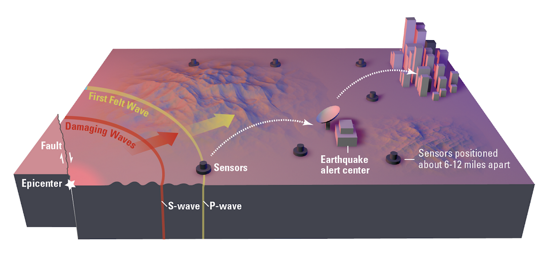
- In an earthquake, a rupturing fault sends out three different types of waves. The fast-moving P-wave is first to arrive, but the damage is caused by the slower S-waves and surface waves.
- Sensors detect the P-wave and immediately transmit data to an earthquake alert center where the location and size of the quake are determined and updated as more data becomes available.
- A message from the alert center is immediately transmitted to users.
Potential Benefits:
- Public Warning – Alert individuals to take protective actions such as Drop, Cover, and Hold On.
- First Responder Mobilization – Open fire station doors for rapid deployment of emergency response equipment and personnel.
- Health Care – Notify medical providers to stabilize and/or stop delicate procedures and maintain critical medical facility operations.
- Utility Infrastructure – Safeguard energy sector grid and other utilities infrastructure for strong shaking with warning alarms and automatic controls to prevent combustions, flooding, and loss of water distribution systems.
- Mass Transit Systems – Prevent fatal collisions or derailments by automatically slowing and/or stopping trains, clearing bridges, and diverting inbound airport traffic.
- Workplace Safety – Employees take protective actions , initiate elevator recall procedures to ground floor, place sensitive equipment in safe mode, secure hazardous materials, and halt production lines to reduce damage.
Limitations:
The earthquake early warning system in California will be able to provide seconds to tens of seconds of alert prior to strong shaking. People may receive a ShakeAlert before, during, or after shaking arrives at their locations. The length of time warning given to any location, before, or after shaking begins depends on a number of factors, including:
- Distance between the epicenter and the closest seismic sensor stations. Generally, the first waves to arrive at a station are the less damaging P-waves that travel 2.5 – 4.5 miles per second on average. The more damaging S-waves travel at approximately 3 miles per second. The closer a station is to the source, the more rapidly the ground motion measurements from an earthquake are identified and the information about the earthquake is sent to the data processing center.
- Data transmission speed over the sensor network from the ground motion sensors to the processing centers for dissemination to end users. Data from multiple stations must be collected and analyzed by the regional seismic networks to issue a warning. Ground motion information must be transferred from each station to the processing center. The existing network utilizes a variety of methods to send data back to the processing center to improve robustness, which includes radio links, phone lines, public/private internet, and satellite links. Delays from packaging and transmitting the data from the station to the processing center and the processing center to the recipient must be reduced to provide useful warning time.
- Geological conditions including type of fault, depth of earthquake event, and geological features in the surrounding areas. Real-time ground motion information received from the stations is used to detect an earthquake and rapidly determine the location and magnitude of the event. Multiple algorithms (a mathematical procedure used to compute a desired result) are used to estimate the earthquake information as rapidly as possible.
- The California Earthquake Early Warning System is based on innovative technology that will improve over time. In rare circumstances, you may receive a ShakeAlert when there was no earthquake.
Advisory Board
The California Earthquake Early Warning (EEW) Advisory Board shall convene periodically and advise Cal OES Director on all aspects of the program, including, but not limited to, the functional areas. The board shall utilize committees, groups, and organizations, including, but not limited to, the California Institute of Technology, the California Geological Survey, the University of California, the United States Geological Survey, and entities participating in the critical infrastructure sectors to fulfill the objectives of the program by supporting the functional areas of the system. The board shall inform the public regarding and provide the public with the opportunity to engage the board on, the development and implementation of the system. The board shall, in conjunction with the director, determine the appropriate methods to provide the public with an earthquake early warning alert.
Membership List
- Secretary of Natural Resources Agency
- Secretary of California Health and Human Services
- Secretary of Transportation
- Secretary of Business, Consumer Services, and Housing
- Speaker of the Assembly appointee representing the interests of private businesses.
- Governor’s appointee representing the utilities industry.
- Senate Committee on Rules appointee representing county government.
- Chancellor of the California State University
- President of the University of California
Upcoming Meetings:
- TBD
Past Meetings:
- June 25, 2025
- September 11, 2024
- Public Notice and Agenda for Sept 11 Meeting
- EEW Advisory Board Agenda for September 11
- Cal OES EEW Presentation for September 11
- Partner Presentation No 1 UC Berkeley BSL
- Partner Presentation No 2 USGS
- Partner Presentation No 3 UC Berkeley BSL
- Partner Presentation No 4 Cal OES Listos
- Meeting Recording
- December 6, 2023
- Public Notice and Agenda for Dec 6 Meeting
- Public Notice Supplement for December 6 Meeting
- Cal OES EEW Presentation for December 6
- Partner Presentation No 1 USGS
- Partner Presentation No 2 Regatta Seaside HOA
- Partner Presentation No 3 UC Berkeley
- Partner Presentation No 4 CGS
- Partner Presentation No 5 Cal OES ETV
- Meeting Recording
- May 10, 2023
- November 3, 2022
- Public Notice and Agenda for November 3 Meeting
- Public Notice Supplement for November 3 Meeting
- Cal OES EEW Presentation
- Partner Presentation No. 1 – Google
- Partner Presentation No. 2 – USGS
- Partner Presentation No. 3 – UC Berkeley
- Cal OES EEW Fact Sheet – First Responders
- FAQ: How to Become a Technical Partner
- Licensing Pathway Step-by-Step Guide
- USGS ShakeAlert Case Study for Transportation
- Meeting Recording
- June 29, 2022
- October 27, 2021
- August 5, 2020
- March 7, 2019
- September 27, 2018
- April 30, 2018
- November 30, 2017
- June 22, 2017
System Operations
The California Emergency Services Act requires the California Governor’s Office of Emergency Services (Cal OES), in partnership with members of the California Integrated Seismic Network (CISN), to develop a comprehensive statewide earthquake early warning (EEW) system in California. The California Earthquake Early Warning System (CEEWS) is comprised of seismic stations, data processing centers, and end-user distribution mechanisms to warn individuals prior to shaking once an earthquake begins.
Within Cal OES, the California Earthquake Early Warning Program (CEEWP) serves as the lead for implementing CEEWS and ensuring its continued long-term success. CEEWP has several components. The first is the California Earthquake Early Warning Advisory Board, which is comprised of state agency secretaries, a county representative, a business representative, and a utilities representative. The board will advise the Cal OES Director on all matters related to the implementation and long-term operation of CEEWP. Second, CEEWP has four (4) work groups designed to engage the stakeholder community and make recommendations to the Advisory Board.
The work groups include:
- System Operations
- Education and Training
- Research and Development; and
- Finance
Of the four (4) CEEWP work groups, System Operations is tasked with implementing, maintaining operations and maintenance, upgrading aging infrastructure, and funding enhancements for a more robust system implementing CEEWS. This project builds upon the state’s existing seismic network (CISN) and implements the proposed strategy to provide a comprehensive and reliable statewide earthquake early warning system vital to emergency management and public safety. In fiscal year (FY) 2023-24, $17.086 million has been allocated to conduct day-to-day operations and setting technical standards for station design, seismic equipment, and data quality.
California Government Code 8587.11 states that CISN shall be responsible for the generation of an earthquake early warning alert and related system operations. There are six core member organizations that collaborate in CISN to monitor earthquakes and collect data to support improvements to earthquake resilience which includes the California Geological Survey, Caltech Seismological Laboratory, UC Berkeley Seismological Laboratory, USGS Moffett Field, USGS Pasadena, and Cal OES. The mission is to operate a reliable, modern, statewide system for earthquake monitoring, research, archiving, and distribution of information for the benefit of public safety, emergency response, and loss mitigation. In addition, CISN seeks to mitigate the impact of future earthquakes by collecting, processing, and disseminating critical earthquake information timely.
Other organizations that contribute data to enhance the capabilities of the CISN, include the following contributing members: University of California, Santa Barbara; University of California, San Diego; University of Nevada, Reno; University of Washington; University of Oregon; California Department of Water Resources; Lawrence Livermore National Lab; and Pacific Gas and Electric.
The CISN collects ground motion data from seismic stations throughout California to rapidly and automatically process this data and produce information about earthquakes occurring. CISN provides this information to the State of California, emergency managers and responders, and to the public and the organization archives the data for use in event review and by scientists and engineers. To learn more about CISN, visit the California Integrated Seismic Network website.
Seismic Station Basics
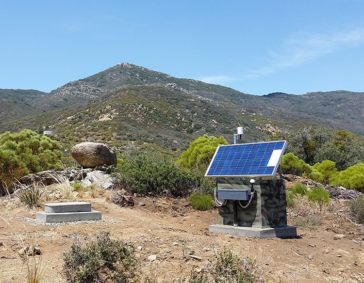
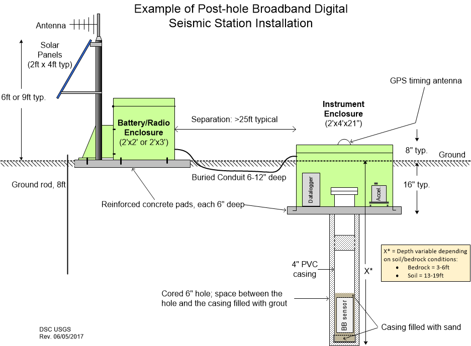
Seismic sensor set-ups may vary based on the landscape, geological features, telemetry capabilities, and contracted partners’ equipment experience.
Seismic stations include 4 major elements:
- Seismic Sensor – all cases in accelerometers (that measure larger ground motion) and some cases include a seismometer (that are more sensitive but cut off larger ground motion).
- Data logging collector and storage unit.
- Power system (which may include solar panels).
- Telemetry equipment to transmit data to the CISN processing centers.
Earthquake Early Warning Seismic Sensor Status
The statewide seismic instrumentation build out has been fully funded, in large part due to the over $127.2 million in State General Funds over eight budget cycles.
As of October 2025, more than 95 percent of the statewide seismic network has been installed. The remaining stations are focused in the less densely populated areas and is scheduled to be fully installed and completed no later than December 2026.
The vision for CEEWS in California was articulated in the May 2016 California Earthquake Early Warning System Project Implementation Framework (the Framework). The framework set a target of 1,115 seismic sensors statewide to achieve the optimum sensor density spacing for earthquake early warning. To maximize warning time and minimize the “delayed notification zone” (the area close to the earthquake epicenter that will likely receive a notification after shaking occurred), stations must be located near active faults. The current goal is to operate a network of seismic stations that are spaced no more than 20-km apart and within 5-km of all mapped fault traces. However, experience tells us that damaging earthquakes can occur even where faults have not been mapped (e.g., 1994 Northridge earthquake); therefore, 20-km spacing or closer is also needed throughout all high-risk areas. A denser station spacing of about 10-km is needed to minimize the delayed notification zone in more densely populated areas.
Visit the Core CISN/CEEWS Partners and learn more at:
Research & Development
Earthquake Early Warning Research and Development (R&D)
Earthquake Early Warning provides individuals with crucial seconds to take protective actions, such as drop, cover, and hold on, and it can initiate automated actions to cease critical operations to mitigate damage. For instance, EEW protocols may reduce property damage, quickly restore operations, and support employee and customer safety. This technology could, for example, reduce the potential for hazmat and fire issues, as well as improve communications following an earthquake. Additionally, EEW protocols may stop elevators, escalators, passenger trams, and conveyor belts to help reduce the likelihood of entrapment.
Research and Development projects focus on creating new pathways for delivering alerts beyond the internet and cellular networks and integrating and applying automated actions into California’s infrastructure and industries.
Challenges to Implementation
A key consideration for R&D is addressing latency, the time it takes to detect, characterize, and model earthquakes, and to deliver targeted alert messages to people at risk from impending shaking. Several factors can contribute to increased latency time, such as location and depth of the earthquake epicenter, proximity of user to the epicenter, operational status of the required four (4) seismic sensors and how close they are to each other, and how quickly the data moves through the system. As per USGS, delivery of alerts and automated actions must occur within five (5) seconds of the earthquake being detected. Cal OES and its partners are researching ways to reduce latency and address the lack of reliable monitoring offshore.
Current Projects Under Development
One method under development to improve latency is datacasting (data broadcasting). Datacasting utilizes extra bandwidth in digital TV signals and is currently used to transmit news, weather, traffic, and stock market information that may or may not be related to the program on TV at the time. This information can also be used to broadcast earthquake early warnings which can be utilized by companies and individuals with specialized receiver equipment. Datacasting is a robust, high speed data delivery method that can provide an alternative to other methods like phone and internet.
Education & Outreach
Tools & Resources
Get alerts on your phone
Prepare for an earthquake
See the latest earthquakes
Report an earthquake you felt
Learn more about our partners
- USGS ShakeAlert
- Berkeley Seismology Lab
- Caltech Seismological Laboratory
- California Geological Survey
- California Integrate Seismic Network
Learn more about earthquake early warning
Legislation
Finance
Since 2016, the California Governor’s Office of Emergency Services has received more than $127.2 million from the California Legislature to support the buildout and maintenance of the EEW seismic network stations, community outreach, and research and development projects. Governor Newsom’s 2021-22 budget, passed by the Legislature and signed into law, secured a recurring annual budget of $17.1 million to complete the infrastructure buildout, operation and maintenance, and fund the remaining activities identified in the initial CEEW System Business Plan.
Earthquake Early Warning Financial Information
- 2026 Business Plan Update – Pending Approval
- 2025 Business Plan Update – California EEW Program Annual Business Plan 2025 Update
- 2023/2024 Business Plan Update – California EEW Program Annual Business Plan 2023 2024 Update
- 2023 EEW Legislative Report – EEW Funding Report for the California Legislature
- 2022 Business Plan Update – California EEW Program Annual Business Plan 2022 Update
- 2021 Business Plan Update – California EEW Program Annual Business Plan 2021 Update
- Implementing Earthquake Early Warning in California – California EEW Business Plan
