Earthquake Preparedness
The California Governor’s Office of Emergency Services, Earthquake, Tsunami and Volcano Program is continuously researching, learning, and developing new ways to improve the safety of California’s residents and visitors before disaster strikes. Through planning and improving building codes, transportation, communications, and education, our staff works with our partners to prepare the people of California to decrease the loss of life, protect the environment, and property. If you live in an area that can be impacted by an earthquake, preparation is vital, as these events can strike suddenly, at any time, and anywhere. Visit My Hazards to see if you live or work in an area prone to earthquakes.
- CalOES Guide and Checklist for Nonstructural Earthquake Hazards in Schools – 2025 Edition
- 2026 Great ShakeOut Earthquake Drill
-
For more information about earthquakes, go to Earthquake.ca.gov
Upcoming Earthquake Preparedness Events
2026 International ShakeOut Day is October 15, when millions of people worldwide will participate in earthquake drills at work, school, or home!
At 10:15 a.m. (local time) on 10/15, you can join millions of people across the world practicing earthquake safety.
While we encourage participation with everyone, you can register your ShakeOut drill for any day of the year, and drill at a time of your choice. You can also include people in multiple locations through video conferencing.
About Earthquakes
Earthquake Causes
The earth has four major layers: the inner core, outer core, mantle and crust. The two outer layers make up a thin skin on the surface of our planet. This skin is made up of many pieces like puzzle pieces (known as plates) covering the surface of the earth. These puzzle pieces continuously move around, slowly sliding past one another and bumping into each other. The surface where the pieces slip and slide is called the fault or fault plane. The boundaries of these pieces are made up of many faults, and most of the earthquakes around the world occur on these faults. Since the edges of the plates are rough, they can get stuck while the rest of the plate keeps moving. Finally, when the plate has moved far enough, the edges unstick on one of the faults and there is a sudden release of energy which we call an earthquake.
Sometimes there are smaller earthquakes that happen before a larger earthquake in the same location (called foreshocks). Scientists can’t tell if an earthquake is a foreshock until a larger earthquake happens. The largest earthquake in a series is called the mainshock. All mainshocks are followed by numerous aftershocks (smaller earthquakes in the same place as the mainshock). After a large earthquake, aftershocks can continue for weeks, months, and even years.
Earthquake Magnitude
The magnitude of an earthquake describes its size. There is only one magnitude for each earthquake. Scientists also talk about the intensity of shaking from an earthquake, and this varies depending on where you are during the earthquake.
The magnitude of an earthquake depends on the size of the fault and how far the plates move. This is not something scientists can measure with a ruler or measuring tape, since faults are deep beneath the earth’s surface. So how do they measure an earthquake? They use recordings (known as seismograms) made on the surface of the earth to measure motion and determine how large the earthquake was.
The recordings look like a series of wiggly lines that appear during ground vibration (see image below). A series of short wiggly lines means a small earthquake, and a series with long wiggly lines means a large earthquake. The length of the wiggle depends on the size of the fault, and the size of the wiggle depends on the amount of slip.
The magnitude of an earthquake describes how much energy was released based on the maximum motion recorded. There are different scales used to convey this information, but the moment magnitude scale, abbreviated MW, is preferred because it works over a wider range of earthquake sizes and is applicable globally.
Magnitudes are based on a logarithmic scale (base 10). What this means is that for each whole number you go up on the magnitude scale, the amplitude of the ground motion recorded by a seismograph goes up ten times. Using this scale, a magnitude 5 earthquake would result in ten times the level of ground shaking as a magnitude 4 earthquake (and 32 times as much energy would be released).
Earthquake Intensity
Intensity measures the strength of shaking produced by the earthquake at a certain location. Intensity is determined from effects on people, human structures, and the natural environment. This means, how strong an earthquake FEELS to people in a certain location or was there damage to buildings or other structures. Intensity is measured using a descriptive scale called the Modified Mercalli Intensity Scale. One earthquake will have numerous values for intensity, as it will feel stronger and cause more damage in areas near the epicenter and lessen for areas further away. Information gathered from people near the earthquake, combined with damage reports, is gathered by zip code and assigned an intensity value (see chart below). This information is then mapped to get an overall picture of the earthquake’s strength.
Earthquake Preparedness
Am I at Risk?
California and Alaska are generally the most seismically active regions in North America*. Maps covering earthquakes over the last 11,000 years indicate that major faults in California could affect 36 counties and 104 cities. Do you know your risk for earthquake?
Knowing if you live, work, shop, vacation or drop your children off in an area that could be impacted by an earthquake fault is the first step you can take to reducing your risk of injury and decreasing property damage from an earthquake. As long as you have an address, you can find out if you are at risk by visiting Cal OES’s “My Hazards” and entering the location zip code.
Once you determine your risk, you can begin to prepare your family, employees, students and others to lessen the impacts of an earthquake.
*In 2014, Oklahoma saw a 500% increase in seismic activity (quakes of magnitude 3 or greater), thereby surpassing California for the first time in recorded history.
Earthquake Preparedness
Preparedness refers to activities we do prior to an earthquake to be ready to respond to and recover from significant ground shaking. When it comes to earthquakes, there are simple things you can do to improve your chances of survival and recovery. Anything you do today will be like making a deposit in your survivability savings account for withdrawal in tough times.
At a minimum, you should be prepared to be isolated and on your own for at least three days and nights. There will likely be the loss of utilities after a disaster. It is possible the power will be out, water may be scarce, gas lines may break, phones and cell towers could become inoperable, roads might be impassible, etc. Your only source of news may well be the car radio, assuming your local radio station has a working generator. There might not be medical assistance for days.
To begin preparing your home and family (From “Putting Down Roots in Earthquake Country”):
- Identify potential hazards in your home and begin to fix them.
- Create a disaster-preparedness plan.
- Create disaster kits.
- Identify your building’s potential weaknesses and begin to fix them.
- Protect yourself during earthquake shaking.
- After the quake, check for injuries and damage.
- When safe, continue to follow your disaster-preparedness plan.
Mobile homes and homes not attached to their foundations are at particular risk during an earthquake. Buildings with foundations resting on landfill and other unstable soils are at increased risk of damage.
Using a cell phone takes up the same bandwidth as 800 text messages. After a disaster, use of cell phones can shutdown wireless phone service and prevent 911 calls from getting through. To communicate after an earthquake, send a text, don’t call. Even if your text gets a “busy signal” the phone will continue attempting to send the message.
Many websites and organizations have published checklists online to help you prepare. Sample Disaster Plans can make it easier for you to customize one for your family, business, non-governmental agencies, schools, utilities, hospitals, governmental agencies, tribes and others . Information for preparing your home, business, family, pets, seniors, children, those with access and functional needs is available on the Cal OES website.
California Residential Mitigation Program (CRMP)/ Brace + Bolt
The CRMP Earthquake Brace+Bolt program offers homeowners up to $3000 to cover costs associated with earthquake retrofitting. A residential seismic retrofit strengthens an existing house, making it more resistant to earthquake activity such as ground shaking and soil failure. The seismic retrofitting involves bolting the house to its foundation and adding bracing around the perimeter of the crawl space.
Homeowners: Is your house earthquake-ready? If an earthquake happened today, would your house stay on its foundation? You may qualify for up to $3000 toward a seismic retrofit of your house.
Contractors: EBB encourages homeowners to use licensed contractors experienced in seismic retrofitting. EBB is free to contractors and to be included in the Contractor Directory all you have to do is take the online FEMA training provided.
Building Officials: Building departments play a critical role in the success of EBB. Participating homeowners need their building permit to confirm the retrofit was done in accordance with Appendix Chapter A3 or an approved standard plan set.
Learn more: Earthquakebracebolt.com
CRMP is a joint powers authority created by the California Earthquake Authority and the Governor’s Office of Emergency Services. CRMP was established to carry out mitigation programs to assist California homeowners who wish to seismically retrofit their houses. Our goal is to provide grants and other types of assistance and incentives for these mitigation efforts and EBB is the first of these programs.
California Earthquake Authority
Most homeowners insurance does not cover damage caused by earthquakes. Read your policy carefully. Go to the California Earthquake Authority for more information on obtaining earthquake insurance in California. California Earthquake Authority is a not-for-profit that provides earthquake insurance policies to California homeowners and renters, and works to encourage all Californians to take steps to reduce the risk of earthquake loss.
Learn more: Earthquakeauthority.com
Prepare Your Workplace
According to the U.S. Bureau of Labor Statistics, American Time Use Survey, in 2013 the average work day for full time employed Americans (age 25-54 with children) was 8.7 hours. An earthquake could occur anytime in that 8.7 hours. Are you prepared? Preparing your workplace is just as important as preparing your home. There are many ways to improve your safety in the event of an earthquake. Here are just a few suggestions:
- Determine if your workplace is in an area at risk for earthquake.
- Be familiar with your company’s emergency plan.
- Know evacuation routes and locations deemed safe.
- Keep a pack of personal supplies (including walking shoes) that can be grabbed quickly and easily.
- Keep a list of emergency numbers handy.
Many organizations play a role in assisting business owners with their disaster planning. See “Tools and Resources” below to get you started preparing before the next earthquake with sample plans, checklists, suggested educational programs for employees, exercise methods, and how to improve plans that are already in place.
Contact your local emergency management office or local American Red Cross chapter for more information.
Earthquake Preparedness for Teachers and Schools
While earthquakes have occurred throughout history, our knowledge and understanding of preparing for them is much more recent. Through planning and education, we are now in a position to ensure the current and upcoming generations make earthquake preparedness a regular part of their routine. As actions from learning to drop, cover and hold on, to securing furniture in their homes becomes the norm, students can take this information and teach their families and friends how to be prepared.
As we learn more, our partners are applying that knowledge to assist teachers, parents and schools in the education of students of all ages and abilities by providing lesson plans, curriculum, activities, games, materials, publications and a multitude of other resources.
For more information on school planning and preparedness, visit the Cal OES School Emergency Planning and Safety web page and our “Tools and Resources” section below.
Earthquake Preparedness for Government Agencies and Tribes
The Earthquake, Tsunami and Volcano Program is responsible for the supporting all California governmental agencies and tribes to ensure the protection and safety of the populace in the event of an earthquake. To this end, the Program staff are available to provide guidance and assistance to our partners in the preparation of plans to mitigate and plan for, respond to and recover from earthquakes impacting our State. In addition, many resources and guidance materials are available for review to walk developers through the planning process.
During the preparedness phase of emergency management, and as part of a comprehensive preparedness program, the emergency management community should develop plans and procedures to be implemented during an earthquake. Plans will need to be flexible and all-encompassing enough to recognize not only earthquakes, but all potential risks and exposures for the community, business, government agency, school, or hospital. Planning activities will vary by jurisdiction but should include the following: Communication, Early Warning, Shelters, Evacuation Plans, Resources and Inventory, Emergency Workers, Volunteers, Training, Access and Functional Needs population, Non-Government Organizations, Multi-Agency Coordination.
Earthquake Preparedness for Businesses and Organizations
Since earthquakes often strike without warning, it is important to be prepared. Developing an earthquake preparedness plan is one of the most strategic decisions you can make if you are responsible for a business or organization. A workplace should follow accepted earthquake safety guidelines, but have in place a personalized, well-rehearsed plan to help safeguard your organization during an earthquake. Developing, and putting into place, a Disaster Plan will not only protect employees, but will help minimize the financial impact of an earthquake, and help you recover more quickly. To prepare for an earthquake, all businesses should:
1. Eliminate potential hazards
2. Make a business emergency plan
3. Train your employees
4. Exercise your emergency plan
5. Have medical supplies on hand
6. Keep disaster provisions on site
Many organizations play a role in assisting business owners with their disaster planning. See our “Tools and Resources” below section to get you started preparing before the next earthquake with sample plans, checklists, suggested educational programs for employees, exercise methods, and how to improve plans that are already in place.
Real Time Earthquake Information
As soon as an earthquake shakes, an enormous amount of information is gathered from people, equipment and first response organizations. This information is interpreted by scientists and computers, and then a number of products are available from warnings to maps of the impacted area. Many of these products are available in seconds or minutes, what is referred to as “real-time”. Alerts may even be produced before your location is impacted (see Earthquake Early Warning).
In most cases, you can sign up to receive real time information through your cell phone, social media, email, etc. Check with your local county emergency management office (see “Tools and Resources” below for websites) to see how to sign up. Other information is accessible virtually immediately online, on television or on the radio.
Earthquake Advisory
What is an Earthquake Advisory?
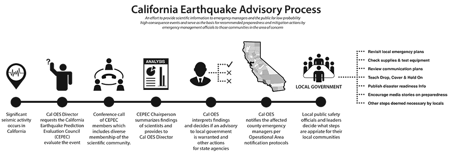
An Earthquake Advisory is a statement that summarizes the scientific evaluation of the California Earthquake Prediction Evaluation Council (CEPEC) regarding the short-term elevated likelihood of a damaging earthquake. The Advisory provides Cal OES’ recommendations for response actions by local emergency services and measures that the public can take for disaster preparedness.
When is an Earthquake Advisory issued?
Advisories are issued following earthquakes in which there is concern about the potential for subsequent damaging earthquakes. The basis of the advisory is existing knowledge of seismic history and potential of the area under consideration.
How is an Earthquake Advisory developed and written?
Cal OES issues advisories only after notification from CEPEC of special concern regarding an evolving sequence and where, in Cal OES’ judgment, there are significant public safety considerations. In the immediate aftermath of significant seismic activity, the Cal OES Director can request that CEPEC evaluate the event and advises on the next steps.
After CEPEC meets to discuss the history and current data regarding a specific situation, the chairperson then provides those details to Cal OES which in turn interprets the summarization of those findings and determines if an advisory is warranted.
Cal OES then notifies the affected county emergency managers per Operational Area notification protocols. Once in agreement, an advisory is then distributed to educate the public.
What is an Earthquake Advisory intended to do?
The purpose of the Earthquake Advisory is to provide scientific information to emergency managers and the public for low-probability, high-consequence events and serve as the basis for recommended preparedness and mitigation actions by emergency management officials to those communities in the areas of concern. Specifically, the Advisory intends to inform the public to consider actions such as: build a preparedness kit; review communication and emergency disaster plans; and practice the “Drop, Cover and Hold On” drill.
The Advisory also encourages local government to publish disaster readiness information, revisit local emergency plans and check supplies and test equipment.
Does California issue “alerts and warnings”?
Yes. Each jurisdiction within the state is responsible for preparing for a disaster, including establishing methods for alerting and warning the public, mobilizing resources and initiating protective actions. At the state level, Cal OES operates the California State Warning Center (CSWC), which is staffed 24 hours a day, 365 days a year to serve as the official state level point of contact for emergency notifications. From this center, Warning Center personnel maintain contact with County Warning Points, state agencies, federal agencies and the National Warning Center in Berryville, Virginia.
Is an Earthquake Advisory considered part of the alert and warning system?
No. The CSWC receives notification of earthquakes from the California Integrated Seismic Network (CISN), National Earthquake Information Center and the United States Geological Survey. CISN is a statewide network that provides the basic information for California earthquakes shown on the CISN Display. The CISN Display is an Internet-based rapid earthquake notification system that receives earthquake information from networks world-wide. The CSWC is responsible for informing, communicating, alerting and notifying local governments, Operational Areas and state officials and the Federal Government of natural or human caused emergencies.
To meet this responsibility, the Warning Center is equipped with a number of telephone, data and radio systems, including the California Warning System, California Law Enforcement Telecommunications System, NWS Weather Wire, CSWC message switching computer, Emergency Digital Information Service, CISN and Dialogic Automated Notification System. Most of these systems are used on a day-to-day basis; others are available for use in an emergency, as conditions require.
Does Cal OES issue earthquake advisories the same way as tsunami watches and warnings are issued by the National Weather Service?
No. An Earthquake Advisory is not equivalent to a tsunami watch or warning, in fact the process is quite different, because the likelihood of an event is less certain. Earthquakes remain unpredictable, even following a potential foreshock, an event is still improbable. Earthquake advisories can only provide emergency managers and the public with uncertain scientific information, but that information can still mitigate the impacts of a potential major earthquake.
Why does Cal OES send an Earthquake Advisory to local government agencies first?
One of the key goals of the Earthquake Advisory is to provide as much available scientific data as possible to formulate appropriate precautions and preventative actions for emergency managers within local government.
How often does Cal OES issue earthquake advisories?
Cal OES began issuing advisory statements in 1985 following earthquakes where the California community of seismologists believed could generate other earthquakes that could put the public at risk. Since 1991, there have been 11 earthquake advisories issued.
Earthquake Recovery
When disaster strikes, life as it was before can be changed forever. You may have lost the ability to live in your home temporarily or long term depending on the amount of damage. Keeping yourself safe is the first and most important step. If the authorities have evacuated the area, do not attempt to return until the area has been deemed safe and officially re-opened. Many dangers exist with damaged infrastructure such as downed power lines, gas leaks, and potentially other hazardous materials.
Insurance Coverage
While awaiting return to the evacuated area you can contact your insurance company to verify coverage information for the structure, contents, and possibly loss of use. Upon return to the area, take many photos of the damage/loss before cleaning it up to thoroughly document your losses. Follow the guidance of your insurance provider to help ensure you get the best result from your policy coverage.
- Contact the California Earthquake Authority for information on earthquake insurance: Earthquakeauthority.com
Local Assistance Centers
Often after a disaster local government partnering with state and federal agencies and nonprofits will establish a Local Assistance Center (LAC). The LAC provides a single facility at which individuals, families and businesses can access available disaster assistance programs and services. The mission of the LAC is to assist communities by providing a centralized location for services and resource referrals for unmet needs following a disaster or significant emergency. At the LAC, there will be resources to assist you in the recovery process. Some resources that may be available include American Red Cross, Department of Motor Vehicles for replacement driver’s licenses and vehicle titles, county recorder’s office for replacement copies of vital records needed to establish your identity at banks or financial institutions when in need of replacement debit cards or checkbooks.
Various assistance programs may be available after State and Federally declared disasters. Typically, assistance is intended to help survivors get back on their feet not to return them to their pre-disaster state.
Check with the local government building and waste management agencies that have jurisdiction in your area; they may have debris removal or recycling programs you can participate in as you begin repairing and rebuilding.
Earthquake Mitigation
There are many different types of earthquake hazard mitigation including, securing nonstructural hazards in your home and at work, strapping water heaters, installing flexible gas service connectors, installing mobile home supports that meet seismic recommendations for your area and the Brace and Bolt program at the California Earthquake Authority.
Being aware of the hazards in your area using the Cal OES My Hazards Program will help you identify where you might need to consider mitigation measures.
Tools and Resources
Tools
- Latest Earthquakes – Worldwide
- USGS Realtime Feeds and Notifications
- California Integrated Seismic Network (CISN)
- Did You Feel It? (USGS)
- CGS Information Warehouse (Maps and Reports)
- Earthquake Glossary
- Ready.gov – Tribal Leaders (FEMA)
- Mobile Home in Earthquakes: How to protect your home and family (Cal OES)
For Children and Educators
- Guide and Checklist for Nonstructural Earthquake Hazards in Schools – 2025 Edition (CalOES)
- California Geological Survey: For Teachers and Students
- The Science of Earthquakes (USGS)
- Earthquake Topics for Education (USGS)
- ABC’s of Post EQ Evacuations – A Checklist for Administrators and Faculty (CalOES)
- Resources for K-College Teachers (USGS)
- Earthquake Home Safety Quiz (ABAG)
For Businesses
- Ready Business – Prepare, Plan, Stay Informed (FEMA)
- Helping Businesses Become Disaster Resilient (BICEPP)
- United States Small Business Administration
- Emergency Preparedness Checklist for Small Businesses (FedEx and ARC)
- Open For Business EZ Toolkit (Insurance Institute for Business and Home Safety)
Publications
- Homeowners Guide to Earthquake Safety 2020 (English/Spanish)
- Commercial Property Owner’s Guide to Earthquake Safety 2022
- Uniform California Earthquake Rupture Forecast Version 3
- ShakeOut Publications, Multimedia Products, Flyers and Posters
- Earthquake Country Alliance
- California Earthquake Preparedness Survey (CEPS) The Study of Household Preparedness: Preparing California for Earthquakes (Alfred E. Alquist Seismic Safety Commission)
- California Earthquake Preparedness Survey (CEPS) Recommendations to Guide Future State Preparedness Efforts
- California Earthquake Preparedness Survey (CEPS) Findings
- California Earthquake Preparedness Survey (CEPS) Facts
Maps
Partners


Get emergency alerts
Wireless Emergency Alerts is a nation-wide system providing lifesaving information for the State of California